Severe Thunderstorm Alert for Brevard: What You Need to Know
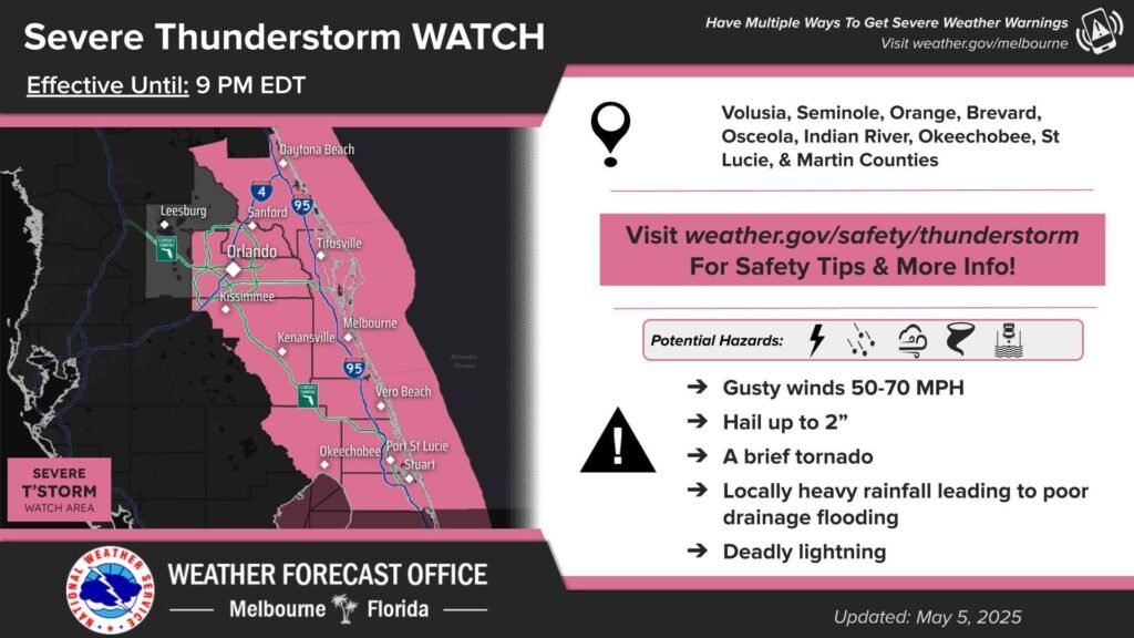
Are you ready for some wild weather on the Space Coast? The National Weather Service has just issued a Severe Thunderstorm Watch for most of east central Florida, including Brevard, until 9 p.m. EDT. Imagine gusts reaching up to 70 mph, hail as big as 2 inches, and even the possibility of a brief tornado. It’s a serious reminder to keep a close eye on the skies—and your weather apps!
Why the Hype? A Closer Look at the Threats
Now, let’s break down the dangerous elements of this storm:
- High Wind Gusts: Expect winds up to 70 mph that can easily knock loose debris and cause power outages.
- Hail up to 2 Inches: Large hail can damage vehicles, roofs, and even sporting equipment—so if you’re planning any outdoor activities, take extra precautions.
- Brief Tornado Possibility: While no tornado is guaranteed, keep an eye on weather updates, especially if you’re in a mobile home or near trees.
- Locally Heavy Rainfall: Sudden downpours may lead to brief flooding, particularly in low-lying areas around Brevard and the greater Space Coast.
For a quick snapshot, check out the table below:
| Weather Element | Forecast |
|---|---|
| Wind Gusts | Up to 70 mph |
| Hail Size | Up to 2 inches |
| Tornado | Brief possibility |
| Rainfall | Locally heavy |
FAQs: Answering Your Burning Questions
Q: Which areas are being impacted?
A: The Severe Thunderstorm Watch covers most of east central Florida, with Brevard taking center stage. If you’re on the Space Coast, stay alert and tuned in to local weather updates.
Q: What precautions should I take during this watch?
A: Keep indoors during the storm, secure loose objects, and avoid driving in hazardous conditions. It might also be a good time to gather emergency supplies and check on neighbors.
Q: Will my outdoor plans be affected?
A: Absolutely. Whether you’re planning a Space Coast beach day or an outdoor sports event, it’s wise to postpone or reschedule until the storm has safely passed.
Q: Where can I get real-time updates?
A: Always rely on the National Weather Service and local news channels for the most up-to-date information.
Local Insight: Navigating the Storm Like a Pro
Living on the Space Coast has its unique perks—spectacular sunrises, rocket launches, and a tight-knit community. But when fierce weather rolls in, it’s crucial to switch gears and prepare for potential hazards.
Imagine your managed MMA training sessions or outdoor workout plans being interrupted by a booming sky. It’s a reminder that even in paradise, nature calls its own shots! So, channel your inner fighter and brace yourself with a game plan:
- Double-check your emergency kit: Batteries, water, and first-aid supplies are must-haves.
- Secure outdoor items: Anything that might get blown away should be safely stored indoors.
- Plan ahead: If you’re out on the beach, know the nearest shelter locations.
Wrapping Up: Stay Safe and Informed
In summary, the National Weather Service’s Severe Thunderstorm Watch is a serious call to action for everyone in east central Florida, especially on the Space Coast. By staying informed and preparing ahead, you can protect yourself, your loved ones, and your property during these turbulent times. Remember, while the weather might throw some fierce challenges our way, a little preparation can go a long way.
Stay tuned to local news and real-time updates, share this post with friends to spread the word, and let’s ride out the storm together. For more detailed updates, safety tips, and local stories, keep visiting our space coast news hub.