Brace Yourselves, Space Coast – Heavy Rainfall is on the Horizon!
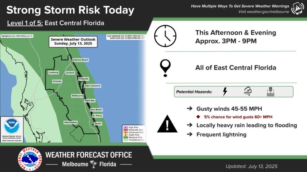
If you’re a local resident or just a weather enthusiast hanging out along the Space Coast, listen up! The National Weather Service has issued an alert: localized heavy rainfall is set to drench our area through Tuesday, and it’s not stopping there. With the potential for urban, rural, and even small stream flooding, plus a marginal risk for severe weather later today, you might want to keep that umbrella handy and maybe even your rain boots at the ready.
What’s Going On?
Let’s break it down. Expect strong storms early this week that could bring more than just a sprinkle. Here’s the lowdown:
- Heavy Rainfall: Continuous showers and heavy downpours are predicted.
- Flooding Risks: Urban, rural, and small stream areas might see rising waters. If you’re near open areas, take extra caution.
- Severe Weather: There’s a marginal risk of severe weather this afternoon and evening. So when you hear thunder, remember the age-old advice: move indoors quickly.
It might not be the blockbuster MMA event you were waiting for, but this storm is one heavyweight we’ll have to contend with. And like your favorite underdog story, being prepared is key to turning potential chaos into a manageable challenge!
FAQ – Your Questions Answered
Q: What areas will be most affected?
A: Although the entire Space Coast is in the storm’s path, urban centers and areas prone to small stream flooding are particularly vulnerable.
Q: When should I be most cautious?
A: The highest risks are expected this afternoon into the early evening, so if you’re outdoors, be ready to seek shelter quickly when thunder rolls in.
Q: Is there a risk of severe weather?
A: Yes, while the risk is marginal, severe weather—so think strong winds and even more intense rain—is a possibility, especially in the later part of the day.
Weather Data at a Glance
For those who appreciate a quick visual summary, here’s a useful table laying out the key weather components:
| Weather Aspect | Outlook |
|---|---|
| Rainfall | Heavy localized downpours through Tuesday |
| Flood Risks | Urban, rural, and small stream flooding possible |
| Severe Weather | Marginal risk, especially this afternoon into evening |
| Safety Tips | Move indoors quickly at the first sign of thunder |
Local Insight – Why Should You Care?
Imagine you’re gearing up for a night out with friends—maybe catching a live sports game or heading to your favorite local spot. Suddenly, the sky decides to put on a water show. It’s not just an inconvenience; it can quickly turn dangerous if floodwaters start swirling around. Staying informed and safe doesn’t just protect you—it also helps our local community hit the ground running (or safely ducking indoors) when the storm hits.
This weather event reminds us that nature can be as unpredictable and thrilling as any fight night. And much like in martial arts, preparation and caution are your best defense.
Stay Prepared & Stay Safe!
So, whether you’re training for your next MMA bout, competing in esports, or simply enjoying the vibrant local culture of the Space Coast, keeping up-to-date with weather alerts is essential. Make sure to check your local weather station for updates, and if you’re heading outdoors, plan your route with extra care to avoid any flooded roads or risky areas.
Ready to take on the storm like a champ? Share your storm preparedness tips and experiences in the comments below and join the conversation with fellow locals!
For the latest updates, remember to keep your devices handy and consider setting up weather alerts on your phone. Stay safe, stay smart, and show this rainstorm who’s boss!
Source: National Weather Service